Adorable second graders pledge allegiance to the flag

students in classroom recite pledge of allegiance to american flag
Photo: Deborah Parks, via US National Archives.

Happy Flag Day! A classroom of second grade students pledge allegiance to the American flag at the Rockport Elementary School in the seaside town of Rockport, Massachusetts, adorably. More adorable.

This photo was taken in Feburary of 1973 as part of the Environmental Protection Agency’s 1970s Documerica project. We’ve had a series of posts on photos from the project.

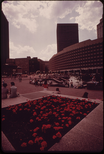
EPA revisiting environment of City Hall Plaza

boston city hall plaza 1973

Photo of Boston’s City Hall Plaza in August, by Ernst Halberstadt, via US National Archives.

This is, let’s be honest, a very flattering picture of Boston’s City Hall Plaza, outside the Government Center subway station.

It’s also the latest in our series of posts on the Boston photos that came out of the Environmental Protection Agency’s Documerica project. One of the themes of photographer, Ernst Halberstadt’s photos were pockets of nature where Bostonians relaxed and cooled down (check out another fantastically pleasant-looking shot of City Hall Plaza) in the hot summer of 1973.

In fact, Boston’s brutalist city hall and surrounding Government Center Plaza, built in the 1960s by a team of three then-Columbia University architecture  professors, Kalmann, McKinnell & Knowles is infamously unpleasant to spend time in. As Fast Co. Design charmingly puts it, “the red brick desert has utterly no redeeming social value.”

The group somehow though managed to win an international design competition for the building with their plan in 1962. McKinnell said the architects were drawn to concrete — not yet a common part of the urban landscape — to make a statement.

He told an interesting anecdote in an interview with Mark Pasnik for the Heroic project. (The project highlighted the concrete structures built from the founding of the Boston Redevelopment Authority in 1957 to the re-opening of Quincy Market in 1976, otherwise known as the catalog of buildings only an architect could love). In their conversation, McKinnell recalled running into renowned modernist architect Philip Johnson, of Connecticut Glass House fame shortly after winning the competition.

[W]e were walking along Madison Avenue, and we spied Johnson coming towards us, waving his arms in typical Johnsonian fashion. “Ah! I’m so happy for you two young boys who have won this competition. Absolutely marvelous. I think it’s wonderful. And it’s so ugly!” We thought that was the greatest praise we could get. And concrete certainly had something to do with that.

The EPA is returning to City Hall Plaza, this time with the Greening America’s Capitals project, which will rethink City Hall Plaza. Paradoxically, this may also be right in line with the architects’ original vision. Also from McKinnell’s interview with Pasnik:

As we all know, Boston’s mayor wants to sell or preferably tear down City Hall. But as Bill LeMessurier once said, it will take a controlled nuclear device to get rid of this building. So in a very real way, perhaps, we have made our legacy using concrete because it is so bloody difficult to get rid of … We were right in the sense that architecture had to be rethought as something which is long-lived and, over time, could be decorated, embellished, and adorned by subsequent generations.

A visit to the farmer’s market in 1973

People at outdoor Food Market at Haymarket Square, bostonErnst Halberstadt, Outdoor Food Market at Haymarket Square, via US National Archives.

The third installment of a series on photos from the DOCUMERICA project.

The Environmental Protection Agency’s DOCUMERCIA project was focused on areas of environmental concern and other land use tensions. Boston’s photographer, Michael Phillip Manheim exhaustively documented the the Neptune Road neighborhood of East Boston’s rocky proximity to Logan Airport. Photographer Halberstadt had a longstanding career of documenting poor urban housing conditions and precarious natural footholds in the city.

He contributed a series of photos to the project of the outdoor market at Haymarket Square, which had been saved from demolition to make way for the Central Artery (along with other parcels of the North End and Chinatown defended by the city) by neighborhood protests.

In other been there, done that news, Halberstadt also brings us this photo of an urban farmer tending his vegetables in one of the more than 400 plots tended in The Fenway Gardens, an outgrowth of World War II-era Victory Gardens, which still operate today.

man surrounded by vegetable plants on boston urban farm, 1973

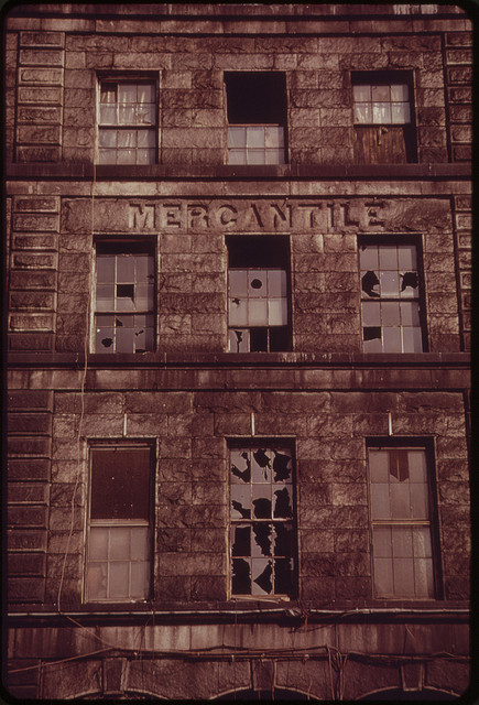
The rise and fall of the Mercantile Wharf Building

brick front of Boston mercantile building with broken windows

Mercantile Building, 1973, photo by Ernst Halberstadt via the US National Archives.

This is the second installment of a series of posts inspired by Boston photos from the EPA’s Documerica project. You can read the first installment on East Boston’s Neptune Road, here.

At the time the Mercantile Wharf Building was erected at Commercial Street and Atlantic Avenue, it was still on the waterfront. Hence the name.

The Mercantile Building was itself built on infill, then beside the water. In these years, much of the new growth on the waterfront was taking place on new land created between some of the old docks, now too small for the latest generation of ships.

It was one warehouse in a maze of support facilities for nearby Quincy Market. Gridley James Fox Bryant, son of the architect attributed with the design of the Bunker Hill monument, designed the building (Interestingly the Bunker Hill monument is attributed with creating a wider market for the granite that prominently features in the carvings and pillars Quincy Market). Bryant is deemed a member of the “Boston Granite School.” Construction concluded in 1857.

This photo was taken between a devastating 1970 fire which raged through the building, and its refurbishment in 1976 with shops below elegant apartments. Today, the building is considered to be an unusually intact remnant of the old harbor commercial architecture.

Along with Boston landmarks, Halberstadt, who, fascinatingly, had also been a WPA muralist captured images of daily life throughout the city in the early 70s. You can find his contributions to the Documerica Project here. The Smithsonian has a transcript online of an exhaustive oral history interview with Halberstadt, which begins with his arrival in Boston aboard a steamship at age one.

The disappearance of Neptune Road

plane flies in low over houses to logan airport 1973Airplane descends over Neptune Road homes to land at Logan Airport. Photo by Michael Phillip Manheim via the US National Archives.

This is the first in a series of posts on Boston photographs from the 1970s Environmental Protection Agency’s Documerica project. The emergence of the environmental movement in Boston in the 1960s featured in an earlier post on the cleanup of the Charles River.

The Neptune Road neighborhood of East Boston was exhaustively documented by Michael Phillip Manheim in1973 as part of the EPA’s Documerica project to photograph areas of environmental concern, modeled on Depression Era Farm photo-documentary projects. 1973 was also the year Massport, which ran neighboring Logan Airport created a noise complaint hotline.

At one time, Neptune Road belonged to a scenic neighborhood of East Boston. Just off the main strip, a large Olmsted Park, Wood Island Park was beautiful and shaded. It reportedly had a bustling street life. The Boston Globe referred to the street as a “miniature Commonwealth Avenue.”

However, Boston’s Logan Airport was also growing in East Boston, and the neighborhood was hammered by major infrastructure projects. In the late 40s, the city’s first expressway cut through East Boston to connect the airport to downtown, cutting off the neighborhood. As the airport expanded, planes flew in low over the residential blocks and conflicts with airport officials escalated. Wood Island Park was leveled early one morning in 1967. The next year, a group of Maverick Street residents barricaded their street to dump truck traffic. The group became known as the ‘Maverick Mothers.’

By the time Manheim arrived Massport had already begun buying up neighborhood homes. Their were a series of death knells for the neighborhood. The demolition of a lone three-decker, 44 Neptune, in the late 90s. What was dubbed the final holdout, 18 Neptune Road, came down a decade later.

Manheim revisited Neptune Road in 2009 with Somerville-based public radio program, Living on Earth. In a telling moment, Manheim got lost trying to track down the old neighborhood in the changed landscape with host, Jeff Young.

MANHEIM: None of this is familiar.

YOUNG: Hmm. Do we have to walk across the tracks here?

MANHEIM: It should be there, I think.

More reading: Open Media Boston has an exhaustive timeline of the 40 years of neighborhood v. airport. And the Utile blog has an interesting and thorough take on Neptune road from a planning and architectural perspective, with satellite images of the neighborhood today. And of course, the rest of Manheim’s images are on flickr.