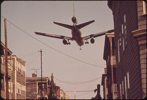
 Airplane descends over Neptune Road homes to land at Logan Airport. Photo by Michael Phillip Manheim via the US National Archives.
This is the first in a series of posts on Boston photographs from the 1970s Environmental Protection Agency’s Documerica project. The emergence of the environmental movement in Boston in the 1960s featured in an earlier post on the cleanup of the Charles River.
The Neptune Road neighborhood of East Boston was exhaustively documented by Michael Phillip Manheim in1973 as part of the EPA’s Documerica project to photograph areas of environmental concern, modeled on Depression Era Farm photo-documentary projects. 1973 was also the year Massport, which ran neighboring Logan Airport created a noise complaint hotline.
At one time, Neptune Road belonged to a scenic neighborhood of East Boston. Just off the main strip, a large Olmsted Park, Wood Island Park was beautiful and shaded. It reportedly had a bustling street life. The Boston Globe referred to the street as a “miniature Commonwealth Avenue.”
However, Boston’s Logan Airport was also growing in East Boston, and the neighborhood was hammered by major infrastructure projects. In the late 40s, the city’s first expressway cut through East Boston to connect the airport to downtown, cutting off the neighborhood. As the airport expanded, planes flew in low over the residential blocks and conflicts with airport officials escalated. Wood Island Park was leveled early one morning in 1967. The next year, a group of Maverick Street residents barricaded their street to dump truck traffic. The group became known as the ‘Maverick Mothers.’
By the time Manheim arrived Massport had already begun buying up neighborhood homes. Their were a series of death knells for the neighborhood. The demolition of a lone three-decker, 44 Neptune, in the late 90s. What was dubbed the final holdout, 18 Neptune Road, came down a decade later.
Manheim revisited Neptune Road in 2009 with Somerville-based public radio program, Living on Earth. In a telling moment, Manheim got lost trying to track down the old neighborhood in the changed landscape with host, Jeff Young.
MANHEIM: None of this is familiar.
YOUNG: Hmm. Do we have to walk across the tracks here?
MANHEIM: It should be there, I think.
More reading: Open Media Boston has an exhaustive timeline of the 40 years of neighborhood v. airport. And the Utile blog has an interesting and thorough take on Neptune road from a planning and architectural perspective, with satellite images of the neighborhood today. And of course, the rest of Manheim’s images are on flickr.
Pingback: The rise and fall of the Mercantile Wharf Building « Looking Backward
Pingback: A visit to the farmer’s market in 1973 « Looking Backward
Pingback: East Boston's Ghosts: Wood Island, Neptune Road, and Massport - Union Park Press
Pingback: Ghosts of East Boston’s Past (and Present) | Green Space Boston